


OXFORD WARD 1, Izard County, Arkansas
About
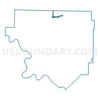
Outline

Summary
| Unique Area Identifier | 526757 |
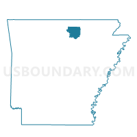
| Name | OXFORD WARD 1 |
| County | Izard County |
| State | Arkansas |
| Area (square miles) | 1.31 |
| Land Area (square miles) | 1.31 |
| Water Area (square miles) | 0.00 |
| % of Land Area | 100.00 |
| % of Water Area | 0.00 |
| Latitude of the Internal Point | 36.22556260 |
| Longtitude of the Internal Point | -91.92252860 |
Maps

Graphs
Select a template below for downloading or customizing gragh for OXFORD WARD 1, Izard County, Arkansas


Neighbors
Neighoring Voting District (by Name) Neighboring Voting District on the Map
- Cleveland Voting District, Fulton County, AR
- OXFORD RURAL Voting District, Izard County, AR
- OXFORD WARD 2, Izard County, AR
- OXFORD WARD 3, Izard County, AR
- OXFORD WARD 4, Izard County, AR
- Union Voting District, Fulton County, AR
- WISEMAN Voting District, Izard County, AR
Top 10 Neighboring County Subdivision (by Population) Neighboring County Subdivision on the Map
- New Hope township, Izard County, AR (956)
- Cleveland township, Fulton County, AR (514)
- Union township, Fulton County, AR (303)
- Baker township, Izard County, AR (203)